Travel

Death Valley Road Trip Part 7

This is the last post in this Death Valley photo log. After the short hike at Mosaic Canyon, it began to rain pretty decently, so we headed back to Furnace Creek.

See Part 1 or Part 2 or Part 3 or Part 4 or Part 5 or Part 6

Did you think that you’d get through this series of photos without an airplane? Hah! Here’s a Piper PA-11 Cub Special, reg. N78659, a the Furnace Creek Airport L06:

A small, blue and yellow high wing single propeller Piper Cub airplane parked on a barren flat landscape with sparse vegetation, set against a backdrop of a large alluvial fan and snow-capped mountains under a cloudy sky.

At Furnace Creek, you can witness the ants of Great-tailed Grackles. Never seen these loudmouth birds before:

Two very black slender Great-tailed Grackles are perched on a streetlamp, one on the top and the other on the supporting arm. The top one is stretched toward the sky and the other Grackle is slyly approaching the top Grackle.

Furnace Creek, which is well irrigated with a golf course, has rabbits:

A rabbit camouflaged among fallen branches and pine needles under a tree.

A Say’s Phoebe. A new to us bird, just off Airport Road there’s a path to a bird watching platform overlooking a pond at the Furnace Creek Golf Course:

A Say’s Phoebe bird, with a rust red belly and gray elsewhere, is perched on the top of a tall brown bushy weed with a grassy field in the background.

The sun managed to shine just a bit on some distant mountains. I was thankful I had my telephoto lens:

A landscape featuring layers of mountains with varying hues, a foreground of dark brown hills, and patches of yellow deposits contrasted against the terrain. The sun illuminates small patches of the mountains.

Sometimes you get unexpectedly striking photos on random road next to an abandoned lot..:

Deserted two-lane road stretching towards sun illuminated mountains under a patchy, wispy cloudy sky.

And that was the end of the trip. I’ll forego posting about the trip back home, since pretty much only the Clown Motel was worth posting about. But if you come to or leave Death Valley via Beatty, Nevada,  I do recommend a stop by EddieWorld for unique candy (and so much more). Thanks for sticking it out! 

See Part 1 or Part 2 or Part 3 or Part 4 or Part 5 or Part 6

Death Valley Road Trip Part 6

This is a slightly shorter post today for just Mosaic Canyon.

See Part 1 or Part 2 or Part 3 or Part 4 or Part 5

We finally visited Mosaic Canyon, which is pretty great for megabreccia:

A person in hiking attire observes a large angular boulder stuck in an otherwise smooth vertical canyon wall.

Mosaic Canyon is also well known for smaller breccia (the “Mosaic", in my opinion!) and smooth dolomite or what most would consider to be marble:

A person hiking on an overcast day through a narrow canyon with breccia overlying dolomite on the left and all dolomite on the right.

A closer view of the cream colored Noonday Dolomite. Plenty here for a geologist to chat your ear off about ;-):

Noonday dolomite bedrock with yellow to cream and white textures, and a portion of a person's shoe in the bottom center. There are swirling strain indicators in this rock. Some rain drops are visible.

Pretty rapidly the canyon broadens as the rocks become marine sedimentary or metasedimentary rocks and thus far more erodible than dolomite:

A barren mountainous landscape with hikers on a rocky dry gray broad braided stream area. The canyon walls are vertical and tan. A mountain with tan to brown to gray colors looms over tiny looking hikers.

After gazing at the amazing erosional surfaces in the sedimentary rock face, one must negotiate steep and smooth dolomite by sliding down it:

A hiker sliding down a steep, cream colored dolomite canyon floor. Beyond the hiker is a vertical wall of sedimentary rock overlying the dolomite.

And that’s a wrap for Mosaic Canyon. Maybe one more part in this series‽ 

Interior view of a car with wet windows indicating rainy weather, visible dashboard displays, and a central touchscreen console, likely a Subaru model, with a view of a barren landscape outside. The dashboard shows it is 67 degrees Fahrenheit outside.

See Part 1 or Part 2 or Part 3 or Part 4 or Part 5

Death Valley Road Trip Part 5

Most of the second full day at Death Valley! 

See Part 1 or Part 2 or Part 3 or Part 4

The next day we drove up to Ubehebe Crater. This northern part of the park was painted yellow in Desert Sunflowers bloom:

A barren desert landscape with sparse vegetation, rocky terrain, and hills in the background. Yellow flowers paint the otherwise drab  slopes yellow.

There were other flowers too, like this striking Notch-leaved phacelia:

Bright purple flowers with green leaves and reddish stems.

And some Browneyes or Browneyed Primrose (Chylismia claviformis):

A person's hand gently touching a cluster of small white flowers with brown centers and maroon-striped petals, growing amidst green leaves and red stems.

The volcanic Ubehebe Crater with person (me) for scale. My wife shot with a Fujifilm X100V camera using a film simulation that’s similar to Kodachrome 64:

A person hiking in a vast desert crater with reddish layered rock walls.

Here’s what I was gazing at through my Fujifilm X-T5 using the more saturated Velvia film simulation to really make the colors pop:

A large crater with stratified red to gray to black rock layers and a patch of mud cracked dirt and scattered vegetation at the bottom. Cloudy sky above.

Here’s the volcanic crater from the top at the north side:

An expansive view above a barren volcanic crater landscape with stratified rock formations in various shades of red, brown and grey, under a cloudy sky. There are rare patches of green vegetation.

And at the same place, a nice vista of the surrounding northern-most part of Death Valley:

Desolate desert landscape with sparse and yellowish vegetation under an overcast sky. Colorful mountains are visible afar.

We headed back south, so we took an opportunity to pull over to gaze at some incredible mountains:

A desert landscape featuring a road in the foreground with sparse vegetation and a mountain range in the background under a partly cloudy sky. The sun lights up the farther mountains, making them stark against the shaded closer but more colorful & clearly faulted mountains near the road.

Uh-oh. A collection of shoes. What could this mean‽:

A collection of discarded shoes and socks on the ground next to a signpost with prohibitive symbols indicating no camping, no fires, no dogs, and no bicycles. People are visible in the background, walking on a paved path in a rocky setting.

The Mesquite Sand Dunes. Clearly, the dunes are famous for gladly taking shoes and socks that people remove and forget (‽) about. Kind people must collect them hoping that the footwear will be reunited with their owners (or someone desperate for footwear):

Sweeping sand dunes with sparse vegetation under a cloudy sky with distant mountains in the background.

 Mesquite Dunes and faulted mountains:

That’s it for today. Stay tuned for Part 6.

See Part 1 or Part 2 or Part 3 or Part 4

Death Valley Road Trip Part 4

Following the lake at Badwater, we went reversed course to the north.

See Part 1 or Part 2 or Part 3 or Part 5

The one-way driving loop for “Artist’s Palette” show-cases up-close Death Valley’s colorful, and VERY faulted geology (holy cow! look for the dissimilarly colored rock abutting each other):

A desert landscape with a clear blue sky, scattered clouds, multi-colored mountains, and several people and a car on a dirt path. The most central mountains appear to be extremely faulted with dissimilar rocks abutting each other.

Lots of volcanic rocks of varying colors at this overlook:

Varicolored mineral-rich hills under a blue sky with scattered clouds. Pistachio green, yellow, brown, and salmon colors.

Very near from the above view, a bit to the south, and there’s another stunning landscape heavily dissected by canyons. The sun briefly peaked through the clouds:

Desert landscape with colorful hills and a winding water cut but dry canyons come together under a blue sky with clouds.

Meanwhile, at Death Valley to the west of us… still pretty dusty but also sun-kissed. Time to leave this cloud provided shade for a little more sun!:

A desert landscape featuring barren hills, with a salt flat visible in the distance, under a partly cloudy sky and a haze of dust. The sun is lighting up the salt flat while all else is shaded. There is a person in the lower left corner of the image.

Back on the road to another part of Death Valley:

A desert road with mountains in the background and a clear blue sky with scattered clouds. In one mid-distance mountain, a stark red bed of rock dips down to the left. The sun partially illuminates the colorful mountains.

Zabriskie Point. It’s easy to see why this is a popular place. It’s just ridiculously photogenic. Apparently this area used to be mined for Borax, but I couldn’t discern signs of that:

Rolling hills of Zabriskie Point with eroded golden-colored badlands against a background of rugged mountains under a blue sky with scattered clouds.

Turn your head from the south and to the west, and suddenly steeply dipping rock and red bluffs named Red Cathedral…:

A rugged desert landscape featuring vertically eroding stratified rock formations with a gradient of brown to yellow to red hues under a soft sky.

The day concluded, we went back to Furnace Creek — the dark green spot on the left. On the right, the palms are on the property of a fancy looking resort:

Desert landscape with rocky ground, a palm tree oasis in the distance, and mountain ranges under a partly cloudy and dusty sky; view from a car window with a side mirror visible. Furnace Creek is the green patch to the left.

Stay tuned for Part 5, which may be the last in the series. See Part 1 or Part 2 or Part 3 or Part 5

Death Valley Road Trip Part 3

Continuing from the Stove-Pipe Wells village, we went to an actual Stove-Pipe Well just to the north.

See Part 1 or Part 2 or Part 4 or Part 5

Here’s an actual Stove-Pipe Well and its historical marker. Visitors have apparently placed glass fragments and pretty rocks along its ledges:

Desert landscape with a historical plaque titled

While we were there we had a crow beg us for food (you may have seen this posted earlier):


We then headed south toward Badwater. We were hoping to visit the Salt Creek Boardwalk for potential pupfish sightings, but it was destroyed by floods. Instead first visited Mustard Canyon near the Borax Works:

A barren yellow hued hilly landscape featuring white, salt-crusted ground with sparse rocky outcrops and undulating hills, set against a backdrop of distant mountains under a clear blue sky. A small ephemeral channel meanders between hills and toward the photographer.

We continued driving south toward Badwater, where the rare and quickly vanishing lake still laps ancient shorelines! For some reason people were wading in the lake at the Badwater Basin trail area:

A vast, arid landscape with a white salt flat in the foreground, surrounded by colorful barren mountains under a blue sky with a few clouds. People are visible in the distance, wading in the shallow lake

Here’s a closer view of the shallow lake near Badwater Basin. We’re not sure what is creating the green tinge. Something is reflecting green somewhere in the lake’s water or lake bed.

A vast desert landscape with a clear blue sky, scattered clouds, distant mountains, and an unexpected brown lake tinged with green near its rocky shore. Snow capped mountains are visible in the distance.

And even closer:

A vehicle parked beside a vast yellowish body of water with a rocky shoreline, under a blue sky with scattered clouds, in a desert landscape. White crystalline material is visible along the shore.

Needless to say, Devils Golf Course was quite underwater. But you can still see some interesting mineralization along the shore:

Close-up of white gray salt minerals at the edge of the lake shore. The minerals look like polyps.

Of course, we had to take a video of the lake:

Okay. We did more that day but this seems like a good place to dock for the night. I’ll leave it at that!

Part 4 to come in a day or so. See Part 1 or Part 2 or Part 4 or Part 5

Death Valley Road Trip Part 1

We had been talking about visiting Death Valley for many years. We finally did it! Here is the first post in a series.

See Part 2 or Part 3 or Part 4 or Part 5

Snow in the Sierra Nevada mountain range along U.S. Route 50 near the “Sierra at Tahoe” ski resort:

A view from the inside of a vehicle showing a road lined with tall pine trees and high snowbanks on a sunny day.

Mono Lake from the vista point on U.S. Route 395:

A panoramic landscape of a snow-dusted valley leading to a large body of water, Mono Lake, with mountain ranges in the background under a clear blue sky.

Sunset behind the Sierra Nevada. Somewhere north of Bishop, CA:

A silhouette of a mountain range with snow-capped peaks against a twilight sky. Ghostly lighting illuminates some whisper thin clouds.

The east side of the Sierra Nevada mountain range, just outside Big Pine. The major mountain might be North Palisade:

A scenic view of snow-capped mountains behind rolling hills with sparse vegetation and a wooden fence in the foreground under a clear blue sky.

Driving by Manzanar, the vile World War II Japanese-American Internment Camp. The Sierra Nevada mountains are in the background:

An expansive landscape with a guard tower in the foreground and snow-capped mountains in the background, below a sky with light clouds. There's dry, brushy vegetation covering the ground, and several informational signs are visible near the middle ground. A barracks building can be seen.

Wind-driven dust on State Route 136, east of Owens Lake:

A view from the inside of a car driving on a straight road through a desert landscape with telephone poles alongside, under a clear sky with scattered clouds. Dust is visible in the air and snaking as ribbons across the road.

See Part 2 or Part 3 or Part 4 or Part 5

Rainbow Canyon near Death Valley

At Death Valley, a Crow Apparently Begs

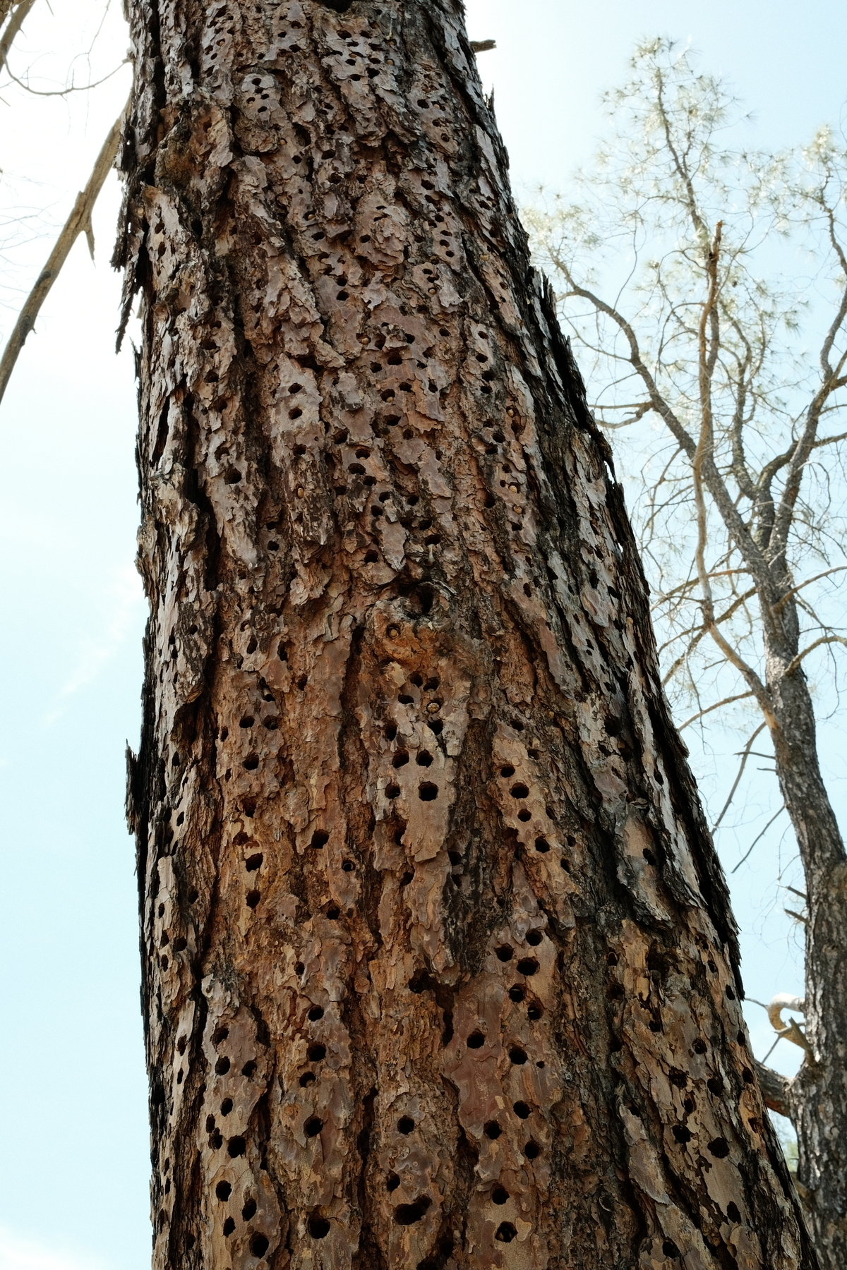
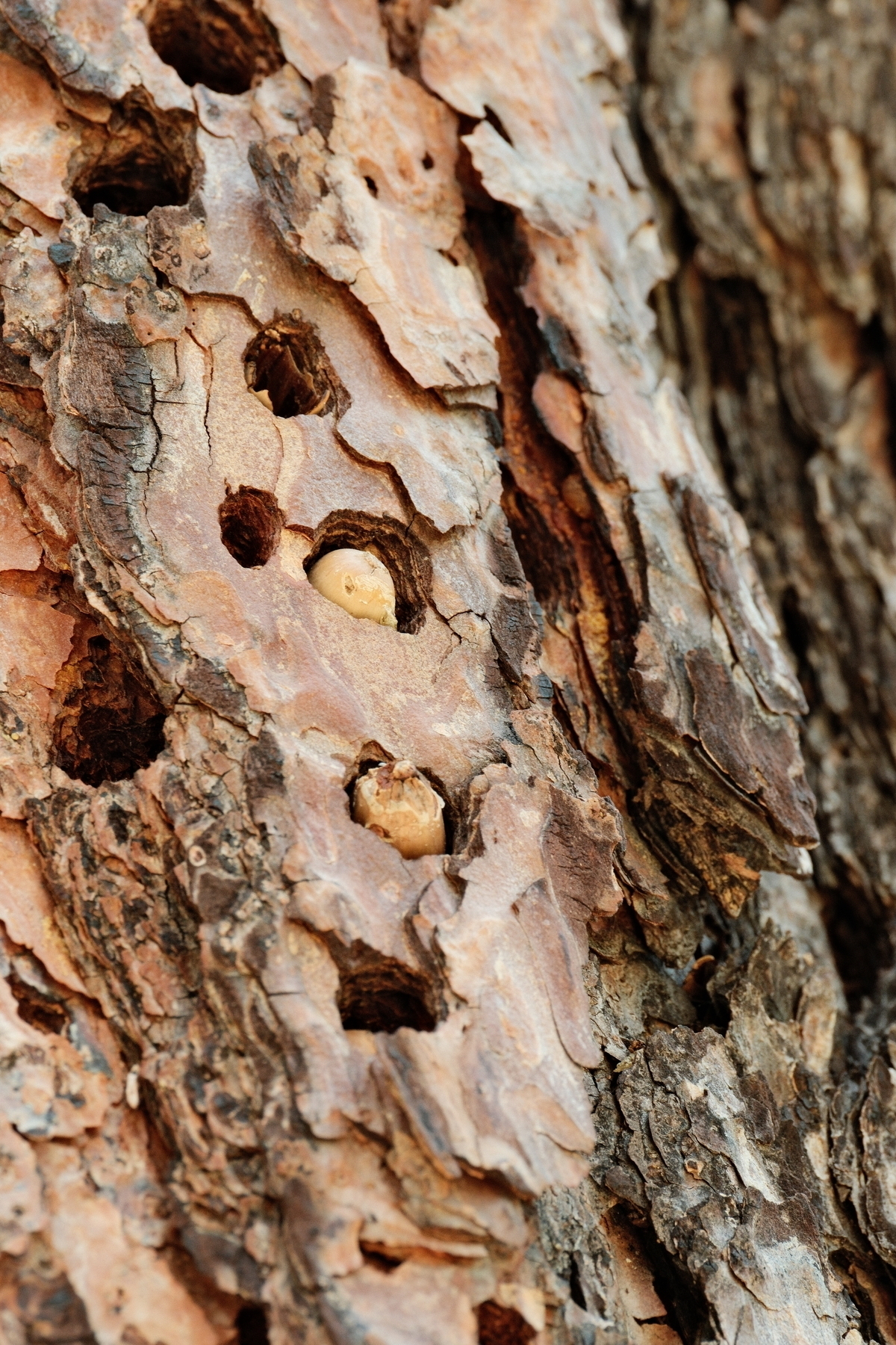
Woodpecker granaries are really neat. This one was right on a trail at Pinnacles NP. We did see an acorn woodpecker nearby though the photo isn’t great.

A dead pine tree pecked full of holes meant for woodpeckers to store acorns.A close up of actual acorns in the holes of the granary.

Last weekend: just a taste of the views you can have at Pinnacles National Park, California, if you take the the High Peaks Trail. #PinnaclesNationalPark #Fujifilm #GeologyMakesThePhoto

Pinnacles of rock jut out of a hilly landscape, with their northsides in shadow and southern sides completely lit up. Vegetation is quite green with a classic kodachrome blue sky and mountain ranges along the horizon.

Last weekend: in its most happiest habitat, predominantly here are Yellow Monkeyflowers within massive rocks at Pinnacles National Park, California. #MonkeyFlowers #PinnaclesNationalPark

Sandwiched inbewteen massive lichen covered rocks are vertical stems of monkeyflowers showing bunches of yellow flowers. The rocks are kind of forming a small channel.

The 2013 Dresden Christmas Market. Guaranteed to make you cheerful no matter how cold it is.

dark evening at the Dresden Christmas Market with a lit up buildings, trees, the tops of sales shacks and a crowd of people

Here’s me on the Snyder Creek trail gazing at the talus field, but still wanting to be out of there (rockfall is the reason for this talus). This is pretty near the end of the trail where there’s a camping area and a paternoster(?) lake, Snyder Lake.Stacey 2022 09 23 11 58 26

Back in September we visited Glacier National Park. We didn't take the Going to the Sun Road, but opted for the lesser traveled Snyder Creek trail. Here's a couple of fuzzy caterpillars taken with a Fujifilm X100V.A yellow fuzzy caterpilarBlack and orange spiky caterpillar

With insanity at European airports I’m thankful our early June trip to Germany was nearly flawless. We 😷managed to not get Corona (we tested ourselves before leaving though the US lifted that requirement while we were there). Almost 4 years of planning! Photo is Frankfurt Intl

Aircraft at Frankfurt terminals

Beetle killed trees in Saxony, Germany.

June 6 in Munich.

June 6, 2022: the higher regional court building in Munich (Oberlandesgericht München).

Germany trip recap: some 787-9 photos while boarding FRA-DEN. I love it when boarding is at a stand and not a gate.

I’m thrilled with this view of Frankfurt International from my hotel room. Great place to end this trip.

Obligatory photo of surfers at the Eisbachwelle in Munich’s English Garden.

Eurasian Coots in the Pagodenburger See at the Schloss Nymphenburg in Munich.

A nesting coot in the lake and a coot on the shore foraging for food.

Elk at Point Reyes National Seashore, California. Last March.

From last Monday near Tomales Point in beautiful California, a genus Arctia moth caterpillar on lupins.

red and black fuzzy caterpillar on slender pinnate lupine leaves.

Random aircraft photo of mine from 2005 at Incheon International Airport, Republic of South Korea. You won’t see lined up 747s like this anymore.08272005 1286 IMG 2580

From Maui earlier this month: a few more early mornings with Haleakala.

sun peaking out from the peak of haleakalaan amazing pink dawn

From Maui: Sea Turtle Part Photos

Here’s a collection of sea turtle parts while on Maui earlier this month. I made ample use of the X100V’s continuous shooting mode, getting several hundred photos and out of those only about six with clearly identifiable turtle parts. They’re amazing creatures and I can spend hours watching them from a distance that won’t stress them out.

You will likely need to tap on a photo to zoom in to see details of the turtle part(s) :-)

Turtle fin: Turtle fin sticking out of the waves

Head of a turtle: Head of turtle peaking out from the waves

Another head: Head of turtle peaking out from the waves

Yet another head with perhaps an exposed shell below and left of the head: Head of turtle peaking out from the waves

Rear of a turtle: DSCF1804 1

Dragon’s Teeth at Kapalua, Hawaii.

Playing with Bulb on my X100V. 7 second exposure of Haleakala at nautical dawn. So cool that I can control the shutter with my phone.

pink glow under wispy clouds above haleakala. City lights abound and sky glow against the sea.

Ethereal light shafts in a coastal forest (Prairie Creek Redwoods State Park in California). From 2015.